Welcome to the home page of the Space Geodesy Programme of the Hartebeesthoek Radio Astronomy Observatory (HartRAO). HartRAO is located North-West of Johannesburg in South Africa.
Geodesy, also called geodetics, a branch of earth sciences, is the scientific discipline that deals with the measurement and representation of the Earth, including its gravitational field, in a three-dimensional time-varying space. Geodesists also study geodynamical phenomena such as crustal motion, tides, and polar motion. For this they design global and national control networks, using space and terrestrial techniques while relying on datums and coordinate systems. (http://en.wikipedia.org/wiki/Geodesy).
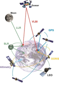
The Space Geodesy Programme participates in global networks which uses applications of Very Long Baseline Interferometry (VLBI) and the Global Positioning System (GPS) to do research in geodesy. HartRAO is an IGS Regional Data Center. HartRAO operates an SLR (Satellite Laser Ranging) system (MOBLAS-6) in collaboration with GSFC, Washington. Having three main space geodesy techniques located on the same site positions HartRAO to play an important role in international space geodesy networks. This collocation makes HartRAO a true fiducial site.
The Future of Geodesy and HartRAO
The scenery of space geodesy is changing as the need has been identified to improve the geometrical distribution of fundamental stations and to improve the accuracy and sampling rates of instrumentation. The location of space geodesy equipment at HartRAO is partially a spin-off from the NASA deep space tracking programme, the consequent CSIR establishment of radio astronomy utilising the tracking antenna, and the efforts from the space geodesy programme to collocate GPS and SLR with the telescope. The site was never “selected” as such in terms of scientific requirements based on astronomical seeing and cloud coverage criteria, so it is not optimally located for scientific output.
The future of space geodesy globally, is in the process of development and installation of dedicated geodetic VLBI antennas, (VLBI2010 project), KHz satellite laser ranging (SLR2000), denser GPS networks (AFREF) and the dissemination of data in near real-time. This concept is termed GGOS, an acronym for Global Geodetic Observing System, which is the first and only project of the newly restructured International Association of Geodesy (IAG). This system will continue to maintain the International Celestial Reference Frame (ICRF) and will provide necessary parameters such as Earth Orientation Parameters (nutation, precession, time etc.) to the global scientific community, astronomy of course being a major user of this product.
Basically GGOS views the Earth system holistically by including the solid Earth, the fluid components and static and time-varying gravity field in its products. This concept combines different techniques, models, and approaches in order to achieve a better understanding of geodetic, geophysical and geodynamical processes. GGOS will provide the scientific and infrastructural basis for all geodetic global change research. This IAG Project commenced with the definition phase in 2003 and is based on the IAG Services.
VLBI 2010 will operate at S, X and Ka bands. The present HartRAO telescope cannot operate efficiently at Ka band (32 GHz). VLBI2010 requires dedicated, 24 hour geodetic measurements monitoring earth rotation to find sub-diurnal rotational variations on the micro-arcsecond level as well as dedicated equipment to monitor Total Electron Content of the ionosphere, maintenance and expansion of the ICRF etc. Currently only 15 % of the HartRAO telescope is allocated to space geodesy which is a fraction of what is required.
Air pollution, proximity of large cities and industrial areas impose severe restrictions on HartRAO as a facility to expand and improve its activities in Satellite Laser Ranging and Lunar Laser Ranging.
Related posts:
Overview
NRF/SARAO is leading South Africa’s involvement in the SKA on behalf of the Department of Science, Technology & Innovation.
![]()